

Where am I going?
Highlight Hiker Blog
Abram S. Hewitt State Park: BONUS MILES!
November 17, 2020 - National Take A Hike Day
Yeah, that’s right. It was snowing on National Take A Hike Day at the higher elevations in West Milford, NJ. Not gonna lie, my face took a little windburn damage from the elements, but to experience those 8.58 bonus miles…? it was kinda’ worth paying the price. The really cool thing about the hike was that, for once, no one else was hiking Abram S. Hewitt State Forest! I mean…. NO ONE. Not a single car parked at any of the lots/pull-offs from the State Line lot to Longhouse Road (where I entered the park). Not a single soul roaming the grounds. I had the entire 2,001 acres all to my little lonesome. WHA’?!?!? When you think about the popularity this park combined with the fact that it was a hiking holiday… that is really quite remarkable.
By now you are plenty aware of my love/hate relationship with Abram S. Hewitt State Forest (ASH). “So why on earth, Highlight, did you go there on National Take A Hike Day?” I hear you say. Well, thank you for asking. I went to ASH because there is a =new blaze= that was opened to the public on September 10, 2020. So while it technically isn’t on the 2017 version of the NY/NJ Trail Conference map (#116), A. I wanted to check this trail off my list before the new publication, and B. I wanted to be the first person to show you the route virtually.
Turns out, though, that the pink trail was a green trail prior to this, so this is actually a re-blazing rather than a new blaze. I’m going to guess (based very loosely about what I have observed) that this trail was closed for some time because of this parks over use. I’m supposing that trail maintainers decided to give this section of the park a break to let it restore itself. And! As I was exploring I learned that apparently there was also a break-off trail from this former green blaze that lead to one of the higher parking pull-offs on Warwick Turnpike which was called The Quail Trail…? If you are a hiker who remembers these trails, please feel free to contact me to give me some history. I would love to know more about it!
But onto the extra credit miles…
With the shorter days of November I wanted to take the shortest route to the pink trail. After scoping my map I realized there is no shorter way, so instead I took my favorite way in via the AT from Longhouse Road. Then it hit me: the last time I was on this trail was this past June… so why not take pictures of the same views from June and put them together in a collage for you to see the differences in the seasons on the trail! I didn’t have a lot of time and I knew with the bad weather that the ridge walk at 1,433’ was going to get slippery, so I didn’t stop to research exactly the angles to precisely line up the comparison photos but working from memory I don’t think I did too bad, if I may say so myself! If you would like to see the entire photo gallery from my June visit, you can find it here.
Today’s hike was a long out-and-back. I started nobo (which is actually an easterly direction here) on the AT, and then turned south into ASH at the Earnest Walker (yellow blaze) trail head. Heading south, I followed the Earnest Walker to the new pink blaze. I followed the pink blaze further south, over the highest point in the park of 1,433’, then down into the valley, crossing Cooley Brook before the trail ascends a few hundred feet to greet the Bearfort Loop (new green blaze). Overall, the new trail is very nice. As a ridge walk fan, this is a fantastic trail when combined with the Earnest Walker. And there is no bad time to visit. In the spring, the leafy new greens and colors of life delight you. In the summer, the ridge offers cool breezes for respite under the hot sun. In the fall natures sense for color and texture abound. And in the winter you get the views! And what lovely views they are spanning over lakes and across the horizon.
I don’t mind all of the trail changes that happened this year at ASH. But there is something that doesn’t sit right with me. Firstly, the wonderful tin trail markers have disappeared and have been substituted with basic paint marks and these… (I hate to say it but-) very poorly… hand written blazes. The new handwritten signs look kinda’ pre-school craft project-y. I wish they would return to the more professional custom printed blazes. You’ll see the difference in the photos. Maybe they are waiting for them to be printed…? Maybe their budget is low and the new blazes will be printed when they have the budget…? I dunno. But seeing neighboring parks managed so well, this really isn’t a very professional look from the ASH park management. I know they do the best they can with what they have, but it just looks… forlorn.
There. I’ve said my peace.
Now go on with your bad self and follow along step-by-step through the photo journal!

I removed Josie's phone number. She's a good soul. No need to have her prank called!

Shortly after entering the forest, you come across my favorite little patch of trees. They stand so straight and tall. They seem to be puffed up and proud!

Comparing June to November in my favorite piece of land.

This is a bridge constructed over an unnamed seasonal creek by Thomas Tracey for his Eagle Scout project.

Comparison photo from June to November.

Looking north from the Scout bridge.

Comparison photo from June to November.

You drop down into a lovely little valley with a huge marsh, which feeds into Greenwood Lake.

You walk next to the marsh for about 3/4 of a mile.

Looking in a south-westerly direction.

Comparison photo from June to November. The log in the foreground is the same, but the angle is off a little.

You walk to the north end of the marsh and hike up the mountain you see in the background.

This area was so lush in June that you could only catch little glimpses of the marsh. And it was filled with birdsong. Today I could see see it's end and the birds were no longer singing.

There is some glacial till here, but for the most part the terrain is easy and smooth. Once you get to the mountain in the background, though...? ALL BETS ARE OFF!

This is a footbridge that crosses Longhouse Creek.

Comparison photo of the footbridge from June to November.

It's such a cute little bridge, isn't it??

Looking north from the middle of the Longhouse Creek bridge.

Comparison photo from June to November

Looking toward Longhouse Creek marsh from the middle of the footbridge.


Peeking through the trees at the marsh.

Comparison photo from June to November

Riverside Road becomes a wide woods road before it intersects with the Appalachian Trail

Comparison photo from June to November of Riverside Road

Looking north on Riverside Road

This seasonal waterway was a mere trickle when I visited in the warm, dry month of June. I still had to cross it by skipping over rocks, though!

Yep. That's the trail!

The AT joins the Earnest Walker once it reaches the heart of Abram S. Hewitt State Forest.

Comparison photo from June to November

The trail head of the Earnest Walker.

Comparison photo from June to November. See what I mean about the tin blazes?

The Earnest Walker trail follows along a high ridge on Bearfort Mountain to the west, and this was the short section I walked to get to the pink blaze

It had been lightly drizzling sleet since I got on the trail, but once over 1200' the sleet turned to snow.

Suddenly Surprise Lake comes into view. That's something you don't see at all in the spring and summer!

Surprise Lake is surprisingly large!

Comparison photo from June to November

Welcome to the the trail: the pink blaze! It might have a formal name, but I don't know what that is!

This trail isn't just a ridge walk, it's a ledge walk. If heights or severe drops make you uneasy, this trail might not be the best way for you to spend your day.

The trail skips in and out of the forest as it passes along the ledge of Bearfort Mountain.

Ledge walking

The trees at higher elevations are beautiful

I couldn't get enough of them.

You'll find that the trail moves between rock and stubby grasses. In most spots, you can opt to walk along either. At other spots it's rock walking or nuttin'! Stable shoes are required.

The moss on the trail hasn't eroded away yet from over use.

Yep! That's the trail!

The snow started to accumulate on my clothes around this mark, the highest point in ASH at 1,433'. I knew that it would eventually melt and dampen my clothes. I had worn several layers, and brought an extra layer in my pack in case I got too cold. I'm so grateful I did because I needed it on my return trip!
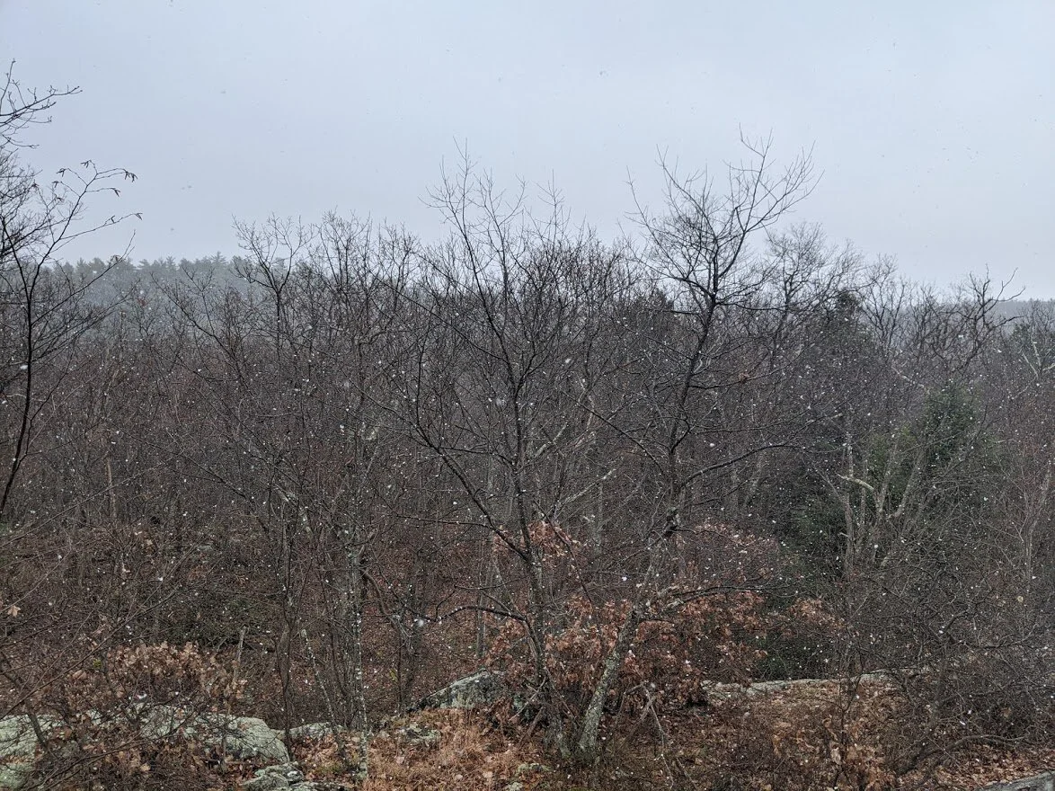
The long view is only overshadowed by the snowfall!

The trail drops down from the ledge gently

As you drift along, the trees go back to reaching toward the sun.

The trail turns and starts to head east toward Cooley Creek.

After a short steep drop through soft terrain, Cooley Brook appears

It was considerably cooler in the valley, and with the snow, wind and lack of sun I really felt the chill more here than on the windy ledge!

Cooley Brook is a mixture of colors

More greens than browns down here in the valley by Cooley Brook.

Yep. That's the trail crossing over Cooley Brook.

Huge slabs of wet rock made the crossing treacherous

Looking south over Cooley Brook.

A quick and steep climb between rocks and soft muddy leaves....

... leads to the trail head at the newly re-blazed Bearfort Mountain loop.

I was so happy to finally turn around. After the temperature drop in the valley, I was feeling quite chilled and with 4.25 miles to get back to the car, I wanted to get moving.

Looking north on the Bearfort Mountain loop (newly re-blazed green)

This is what I'm tlaking about with the poorly written new trail markers. See what I mean? it's barely legible at the bottom. Is that supposed to say Surprise Lake? Surmasilla? I mean.... Suppmarsala?????

Skipping quickly back past Cooley Brook.

THE SUN!! This was the only direct sunlight I got all day and it warmed me for about 45 seconds before going back behind the dense cloud cover.

But in that 45 seconds, the forest lit up!

Meanwhile, heading back to the ledge...

... and that view! I love the clouds hanging low at the horizon.

Walking back on the ridge of the pink trail

Yep. That's the trail!

And that's the prettiest view!

It takes sure footedness to confidently walk along the spine of the ridge in certain sections of the pink.
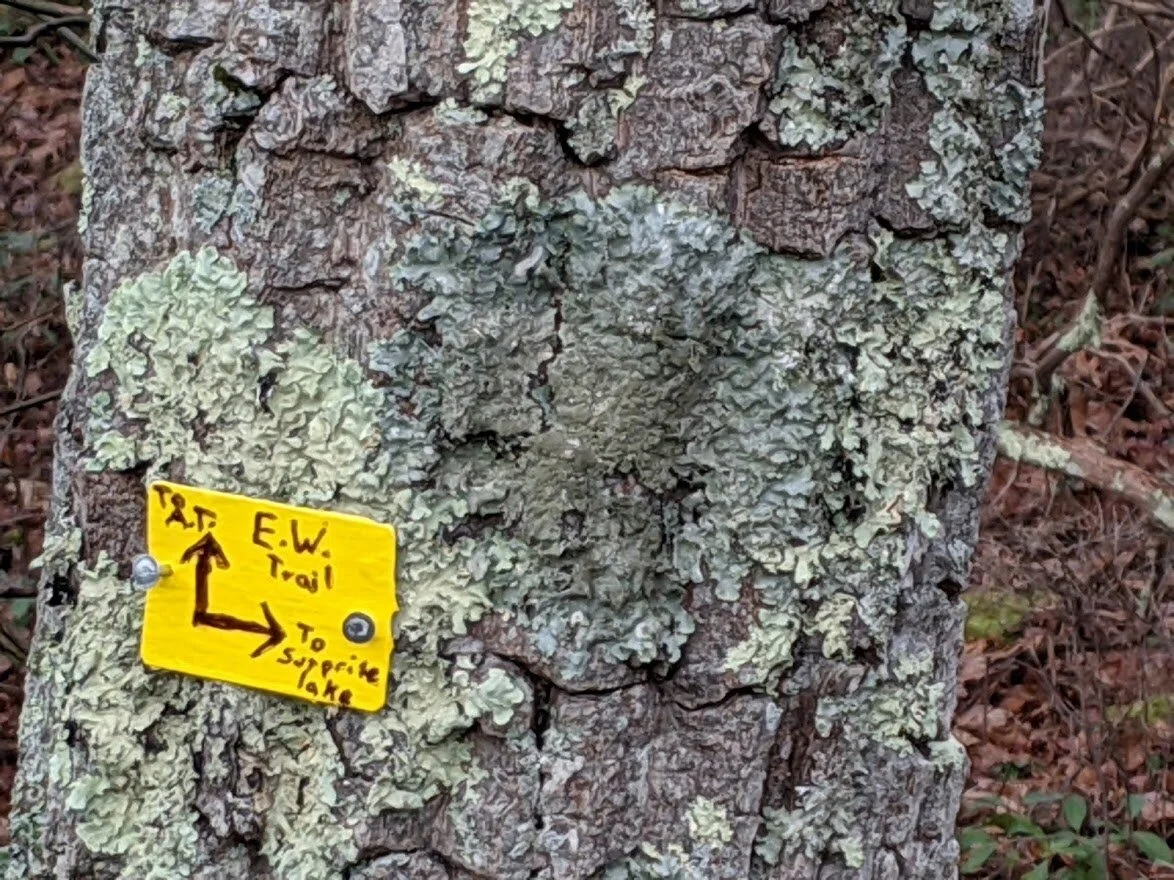
Here's another example of the new trail markers. I really hope these will be replaced. If not, I might raise money for the park to have them replaced.

Back over the Surprise Lake view on the Earnest Walker

The clouds broke up and reflected in the water. This would be a wonderful viewpoint on a clear, sunny winter day.

And the last view over the marsh as the sun dropped out of the sky for the night. I really had to pick up my pace to get back to the car before dark, but I made it... by just a few minutes, sure... BUT I MADE IT! hahaha.