
Where am I going?

Highlight Hiker Blog
April 28, 2021
Norvin Green State Forest
New Weis Center
Otter Hole to Macopin
I want to talk to you about maps.
Since the covid lockdown, a lot more people have been finding their way to the woods for respite. Which is great. My hope is that it will teach the greater population about conservation and preservation of our natural areas.
However, the NY/NJ Trail Conference has had to reroute numerous trails throughout most parks for two reasons: the dramatic increase in hiker rescues, and demands on our beautiful natural resources.
All of that work and cost (both the rescues and the reroutes), could have been avoided had recreational explorers realized there are….
FREE DOWNLOADABLE MAPS
YAY
Yes, NY/NJ TC and Avenza Maps have created free downloads to some of northern New Jersey’s most popular hiking spots to keep hikers safe. Which is great! I mean, personally I love paper maps and I use both in tandem with my downloaded maps but any guide is a good guide when you’re lost, confused, turned around, or generally can’t find your way in a forest.
I regularly have hikers stop me to ask if I know where they are. I always let them photograph my map and/or inform them about Avenza Maps. And they all say the same thing. Every single time.
“Oh yeah. A map would have been helpful.”
So a word to the wise - plan your route and bring a map. Especially if the map is free and downloadable with a great app. And failing all else, take a photo of the map at the kiosk at the beginning of your hike if one is provided.
Avenza Maps does not pay me or give me any kick back for my telling you this. I tell you this because I care about you and don’t want you to get lost. Plus learning to read a map is fun. Oooooooooor… is that just me???
PSA over.
Now on to my short hike through Norvin Green. New Jersey summers can be brutal. Temps in the 100’s with humidity and a blaring sun. Much like with altitude, you kind of need to acclimatize to NJ summer weather. April 28th was the first of many opportunities to adapt to east coast conditions. I knew well enough to keep my hike short and sweet.
Starting at the New Weis Center, I walked south down the Otter Hole trail (green blaze) to the Macopin trail (white blaze). Up and over the west side of Wyanokie High Point using the Wyanokie trail (blue blaze) which is combined with the Mine trail (yellow blaze).
The hike was cool but the best thing I saw were the old homesteads that were on the east side of the Otter Hole trail right at the start. Cellars, a well, and some other ruins are still visible, but with a lot of overgrowth coming in, they may be hidden among shrubs so keep a sharp eye out for the well, and be careful where you step. I don’t want anyone falling into a cellar covered by growth!
I wish I knew the story of this area so I could share it with you, but I haven’t had time to do a lot of historical research as of yet. I’ll update the post when I learn more.
The rest of the hike was pretty typical Jersey Highlands: rocky, rooty, ups and downs and pretty, tall trees beginning to leaf out.
The Macopin is a much easier route to use if you want to get the High Point. It’s longer than the Wyanokie and you’ll still climb, don’t get me wrong, but it’s nothing like the steep, rocky incline on the northern side of the mountain.
So, without further ado…. the gallery!

Total Mileage:.
3.12 miles
Total Elevation:
643 feet

The parking lot at the New Weis Center is enormous, but it does fill to capacity on weekends and in the summer and there is no alternative parking. Street parking is monitored and you will get ticketed/towed.

Once the natural pool is open, picnickers will arrive very early and spend the entire day here, so arrive earlier then normal to get a coveted parking spot.

There are several kiosks in the New Weis Center with a lot of great info.

The New Weis Center has several buildings in various states of repair. The buildings I photographed are just off the main path, but there are more.

The trail through the New Weis Center is expansive, but I didn't explore much. I just went right through to Otter Hole.

The path through New Weis Center that leads to Norvin Green is pretty throughout the year.

You will often see volunteers maintaining the grounds and the garden.

There are two designated paths: one goes through the middle of New Weis and the other is the roadway. Dogs are NOT allowed on this middle path through the Center.

Well manicured pathways lead you around New Weis Center.

The kiosk in the middle of the New Weis Center is the most extensive and lists community events as well as hiker information. It is regularly updated.

A sampling of the info the kiosk for New Weis Center.

In case you want to go do some stuff here.

The opposite side is for NY/NJ TC and has all the Norvin Green info for hikers. See? A MAP!!

There is too much dog instruction signage for you to "accidentally" miss and walk through the Center with your doggo. Please respect these requests.

You can't avoid the signage.
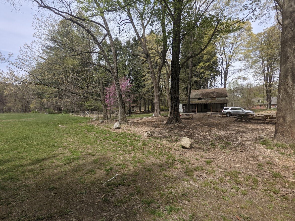
Some of the buildings here look like they are about to crumble and fall.

Picnic spots line the path but they are numbered, so I can only suppose that you have to register? You can research this at the New Weis Center website.

A large field for games, volleyball, picnics, etc. but no music, and no alcohol.

The natural pool is very interesting, but this early in the year, it is not open. They was a dude cleaning it out and getting the place ready, though!

There is yet again another kiosk when you come to the natural pool area.
The Norvin Green border lies just beyond the natural pool.

There are these cute trails that have different blazes: L blaze, music note blaze... I'm assuming these are specifically for the New Weis Center and not associated with Norvin Green nor are they maintained by the NY/NJ TC.

Looking down at the natural pool when it is empty.

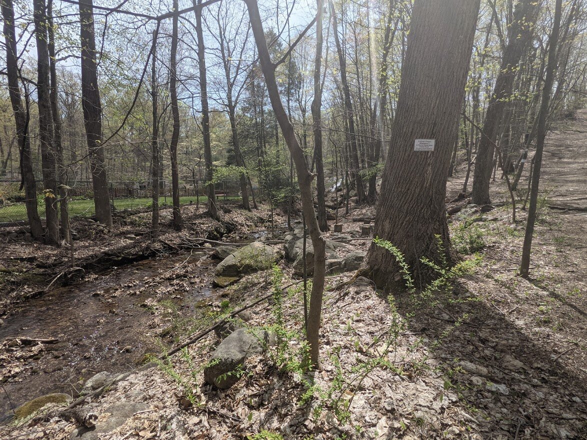
This is the Blue Mine Brook that feeds into natural pool.

The trails that lead from New Weis to Norvin Green are well used and easy with a little bit of incline.

Certain trails are closed in the New Weis Center, but all Norvin Green trails are currently open.

This adorable bridge is sturdy and appreciated!

Otter Hole trail follows alongside Blue Mine Brook leading out of New Weis Center into Norvin Green.

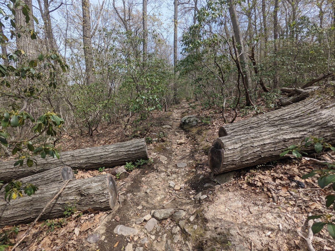
When I say "easy" this is what I mean.

This is the last kiosk and is maintained by NY/NJ TC.

I thought this was a great sentiment and THANK YOU Richard Warner!

These are the bricks!

Down the Otter Hole trail this Blue Mine Brook crossing is a bit more meaty, but not difficult. There are two options to cross. I choose the one on the left. The two people in the distance were really great to talk to.

This is the crossing choice on the right and the sweet couple from the previous photo picked this crossing.

The Otter Hole trail is very pleasant. It is the direct path from New Weis Center to Otter Hole parking lot. While rocky, it's wide and well graded. Perfect for casual walking.

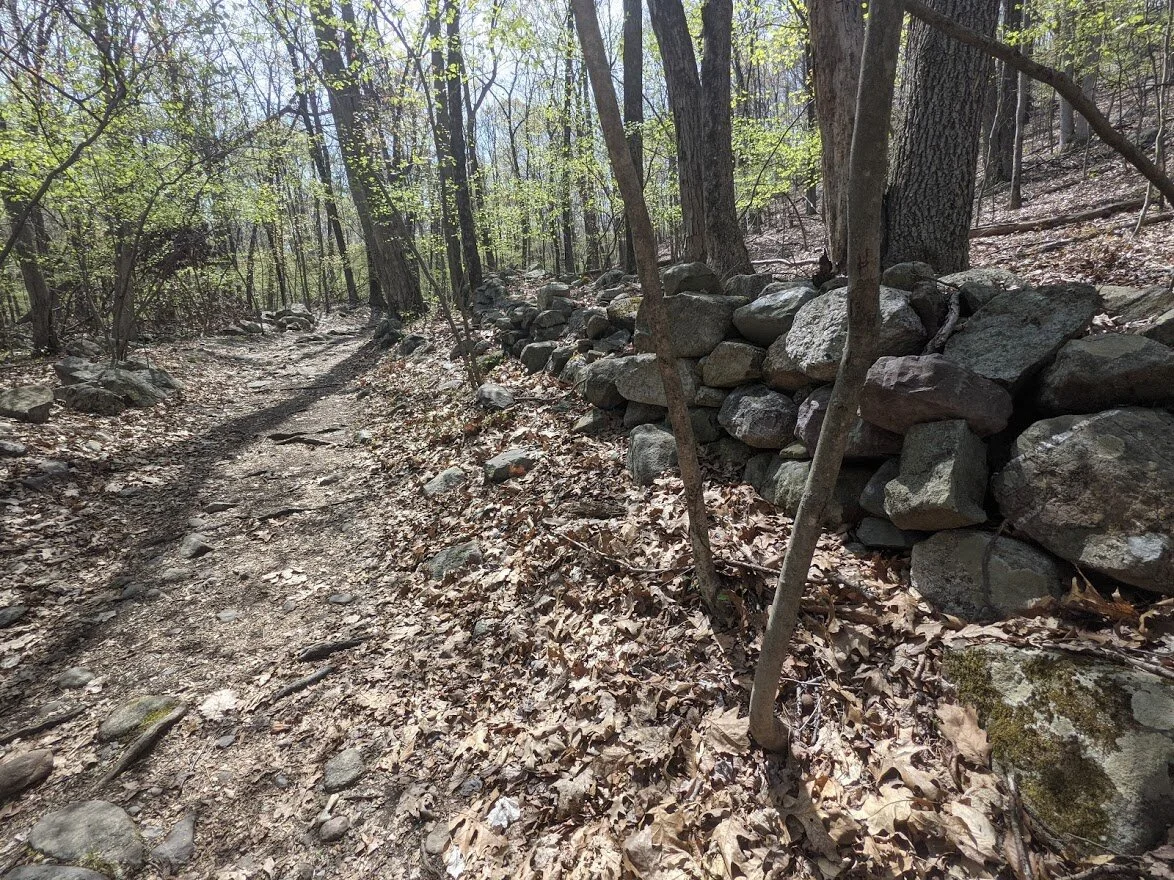
When you get to the wall, you know you're getting close to the homestead ruins.

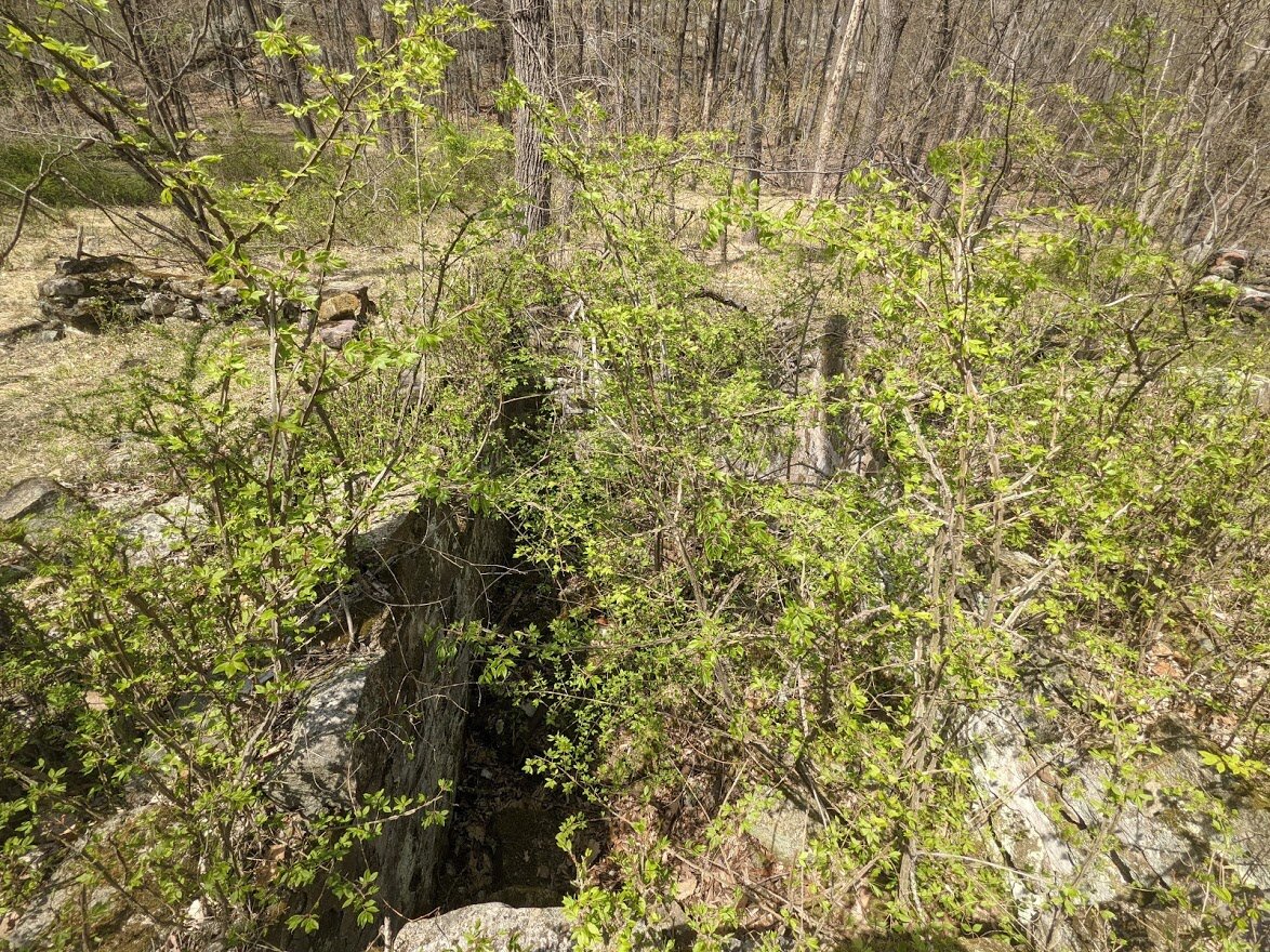
This is the well from the trail, it is the only clearly visible remnant from a gone by era.

At first I thought it was an fireplace or an oven, but as I got closer I realized it was a well.

From above the well.

Good thing someone thought this was a garbage can and threw their coffee cup into it.

You can get a sense of the overgrowth... it's still early spring so it will only get more dense as time goes on.

Cellar ruins

More home ruins.
A second cellar

The forest is really spectacular all around you, and the trail weaves in and out of trees and rock.

After exploring the ruins, I continued along the trail. It started to climb above the woods road, but I saw a lot of people walking along the woods road. They asked me if I could tell them where they were.

The trail has a few geologically interesting points which litter your path with ancient rock dragged down by glacial ice.
As you head up the hill there are more stone walls from former homes.

Otter Hole is a fairly straight trail, but does have a few turns that you need to watch for lest ye follow an unmarked path and get yourself lost.

Just before the Macopin (white blaze) intersects with Otter Hole, there is one last crossing of Blue Mine Brook. This is a very easy crossing.

The intersections are well marked in Norvin Green - moreso than other parks. I'm not sure its really needed, but it is appreciated!

The Macopin begins in a swampy area with lots of skunk cabbage.

The Macopin is typical Jersey Highlands. There is a lot of tumbled jumbled rock covering the trail, but once you get above it, the terrain eases up significantly.

And of course it's well maintained by NY/NJ TC.

The trees are just about to burst with leaves.

There are two steep hauls up to Wyanokie Point, this is the first.

Once it gets to the top, it's pretty smooth sailing until you get to the last climb.

And it is a really, really pretty walk through the woods.

If you look through the trees on the right, you'll see a rock face. Yes. Yes that IS where the trail is taking you.

Then you have this... your last climb to Wyanokie High Point.

The Macopin dead ends at the Wyanokie trail (blue blaze)

From that point you can go further up to the highest elevation, or you can begin your descent. But this is New Jersey, remember? You have to go UP to go DOWN.

But just up the climb is a great scenic view so it's all worth it!

I am saving the highest part of the High Point for a clearer day, but this is just one of the viewpoints on the way back down. This is looking south over Norvin Green.

Panoramic view from this one spot.

I picked up a lot of trash from this scenic view point. It was kind of pathetic how much I packed out from this one spot.

Just a little further down you get this view over the north end of Norvin Green and New Weis Center.

The trees do partially block the view, but it's beautiful anyway.

And you can capture it at just the right angle to see through the trees for a beautiful photo.

Looking out over the Jersey Highlands.

Woodpecker buffet.

I didn't know if I would be able to squeeze through here without scraping up my legs, but I was fine!

The trail is a lot less strenuous going down than up!

The hike down is really fun. I did not use poles nor did I feel I needed them, but I'm sure plenty of folks would disagree. I think it's whatever you're more comfortable with.

There are certain sections that lull you into false security to thinking that the hard part is over, but it isn't!