

Where am I going?
Highlight Hiker Blog
October 15, 2020
Newark-Pequannock Watershed, Echo Lake East - REALLY far east
Tell me: how much of your geology class do you remember?
Because you’re going to want some of it fresh in your memory when you’re hiking Echo Lake East. If you’ve been following along my journeys for some time, you’ll remember my Echo Lake East facebook post. Well, I have returned to cover another remote edge of map #116.
The Watershed is perhaps the best example of geological erosion and deposition in northern NJ. While you’re taking your time to pick over rocks that vary in size between a child’s shoe and the cab of a semi, it’s helpful to remember where they came from to keep from cursing at them. Well… if you’re anything like me, you’ll curse at them anyway…. but it’s still great to understand what happened here.
Now think back. Back. Back to the time when you were a student in class. I want you to imagine yourself at your desk, the smell of pencil shavings, and note passing. Yes. Those primeval times. Think back to your teacher telling you that ancient glacial water would melt and get into the cracks of rock, and then the water would freeze and the rock would crack and eventually separate. Do you remember? Yes. You’re right. It IS called glacial erosion.
But the rocks didn’t just tumble down the mountain, because, y’know… GLACIERS. As the the glaciers melted, they began to sink down from the high flatbeds, dragging these eroded rocks with them. Some would follow the glacier to the bottom of the valley (where the glaciers would eventually melt to create lakes, ponds, rivers, etc.), but some would get stuck and end up deposited, unwaveringly, in strange positions and places. That’s glacial till and glacial erratic, respectively.
I think the coolest thing are striations. These are grooves or scratches that the erratic left on flatbed rock while being dragged down into the valley by the glacier. You know why they’re so cool? Because they show you the direction in which the rock was pulled. It’s the lands language from millions of years ago.
Generally speaking, you’ll find that mountains/hills that have been affected by this ancient glacial practice of erosion have one “smooth” side (this side is where the water was freezing and breaking up the rock), and one “rocky” side (this is the side/direction that the glacier melted… in other words, the direction the rock was dragged). Echo Lake East and the eastern edge of the Highlands Trail are the best example of all of this within 3 miles of hiking.
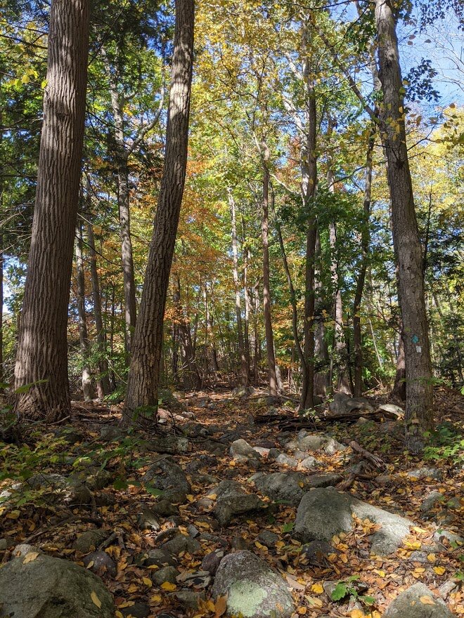
The eastern edge of Echo Lake is a mess of rock. Even an experienced hiker will find it tough to keep up a regular pace. The terrain is so densely packed with deposited rock and it varies in size depending on what is above you. If you look up when you see the largest of the erratic, you won’t see much rock above you. But where the rocks are small and scattered across the trail so that you nearly lose sight of it…? You look up and see mammoth sheer rock walls above you. If I were a teacher I’d say, “What does that tell you? Anyone?” But I’m not. You’re welcome. But there will be a quiz after the photo journal, so pay close attention.
The interesting thing about this hike, though (and the trail blazers did a sensational job picking a route up the mountain for the Highlands) is that within maybe 250 vertical feet of climb and the terrain is smooth and even. Nary a rock to be found. It’s such a great example of nature at work and it’s right here in northern New Jersey! While it would be great to go to Yellowstone or the Rocky Mountains to get this geological lesson, you don’t need to! Just get yourself a $14.00 hiking permit and take the kids over to Echo Lake to get a “boots on” lesson in ancient glacial movement.
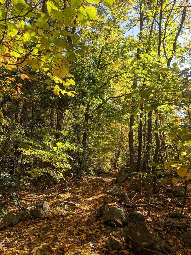
I have a real love/hate relationship with Echo Lake East. I love it for the impression it leaves me with - you can really feel the power of nature here. But I hate it because it takes for-ev-er to hike one mile along the eastern bank of the lake. And it isn’t just the rocks, its the roots that have grown between the rocks. This place easily has the greatest potential for hiker injury. What do I always say, though folks? The greater the challenge, the greater the reward. And autumn on the Highlands Trail is worth the challenge. I’ve never seen so much color in the trees, plus there is a stand of the tallest pine trees I’ve seen in all my hikes through NJ. I walked down a true carriage road and I slogged my way through marshland thick with fern growth. It’s a beautiful stretch of trail east of the lake and I highly, highly recommend it. I hiked a total of three miles in and three miles back through the Macopin region all with a huge grin on my face.
I didn’t expect much from this hike, to be honest. Looking at the map I was just kinda’ “meh” about it. But pleasant surprises abound throughout the Watershed. Due to the marshland, I do not recommend this hike in the spring. Wait until the summer has dried out the swamps a bit. To slog through the glacial till and then to slog through mud and muck would be frustrating work. But at the peak of fall colors…? VOILA! You have geological perfection at your fingertips.
NOTE: ALL HIKING WITHIN NEWARK-PEQUANNOCK WATERSHED REQUIRES A PERMIT. THE ANNUAL PERMIT COSTS $14.00 FOR NON-RESIDENTS AND IS CHEAPER THAN THE FINE YOU’LL GET IF CAUGHT HIKING WITHOUT PERMIT. YOU CAN PURCHASE YOUR PERMIT ONLINE OR AT THE WATERSHED OFFICE ON ECHO LAKE ROAD IN WEST MILFORD, NJ. FYI: THE WATERSHED IS REGULARLY PATROLLED BY RANGERS ON WEEKDAYS AND WEEKENDS AND IS FIERCELY PROTECTED BY REGULAR HIKERS WHO WILL REPORT CARS WITHOUT APPROPRIATELY DISPLAYED PERMITS.
**everything I know about glacial erosion and deposition I learned by reading Tristan Gooley’s book ‘Lost Art of Reading Nature’s Signs’. I have over-used the Newark Watershed website in my “explore it” button, so I opted this time to direct you to Mr. Gooley’s website instead.

While there is pull-off parking right at the trail head for Echo Lake East, it is for official Watershed vehicles only. This means you have to park at the Watershed office and walk a few tenths of a mile along Echo Lake Road (which can be a white knuckle experience).

Plenty of parking available but you gotta' have a permit!!

What makes walking down Echo Lake Road more frightening than other road walks? The cars, buses, trucks, and motorcycles all drive above the speed limit. And you're walking toward it. It can be a bit unnerving.

The worst part of Echo Lake Road is the overpass. And it ain't a short walk, neither.

Safe and sound at the trail head

Mind the gap!

To the east of the trail are the high cliffs where the glacial ice was pulling down the eroded rock. You can actually see the direction in which the ice flowed.

And this is a nice sample of glacial erratic: this boulder was as tall as me!!
Yep. That's the trail. And this was the easy part!

On the west side of the trail lies Echo Lake, which was formed by ancient glacial melt.

The wide variety of colors glisten in the sun

Here you can see an example of cracks in the rock where ancient glacial water would seep into and then freeze, thereby separating the boulders from the flatbed. If you look really carefully you can see some striation.

The largest of erratic on the trail stands at an impressive 10' feet tall: that's twice my size!! Some jerk, though, spray painted the other side in a demonstration of his/her love to someone. =insert==eyeroll==here=

The trees have established themselves between the rocks over the years and the trail is a bonafide tripping hazard.

Add to it the leaves that have fallen and you have no choice but to slow your pace and take your time.

But that's ok because the lake views are worth the lingering pace

Echo Lake scenic viewpoint

Looking north from the Echo Lake scenic viewpoint

Keep in mind that these rocks are wobbly and you're moving uphill. It's a great bi-lateral work out

Echo Lake peeks out through the trees along the trail and you walk very near the edge at a few points.

You can actually see where the glacial water ran down through the rock. It's cool, right??

It's cool AND pretty!
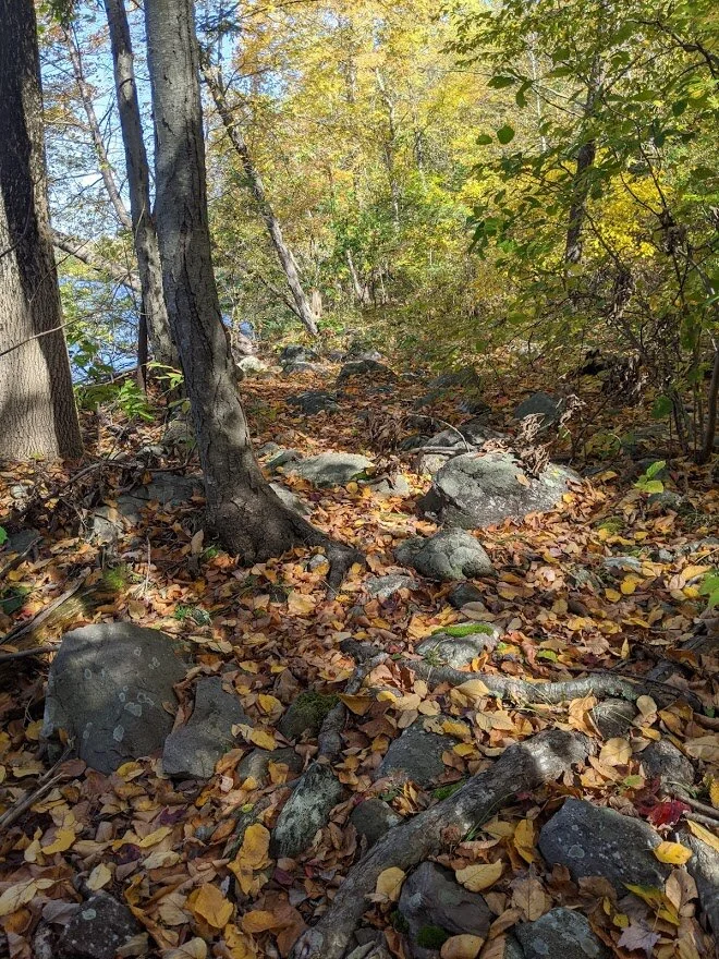
What's worse to hike over: tree roots or boulders?

It's right around here where the trail divides that you notice how slow you're moving. A typical 22-minute/mile pace will easily slow to a 30+ minute/mile pace with the terrain. That can frustrate some. But if you find yourself perturbed by this, remember a little Highlight-ism, "It doesn't matter when you get there, it only matters that you get there"

When you turn east and start heading uphill, the terrain changes dramatically and quickly from densely packed shoe-sized rocks to flat and even terrain.

The Highlands Trail is a trail less traveled, and I'm really not sure why. It was lovingly created in 1995 and is some of the nicest walking throughout New Jersey.

See the difference in terrain just 200' feet above Echo Lake?

Looking back toward the lake, you can just catch a glimpse of the water through the trees.

I always felt that leaves are like an orchestra. When you hear all of the instruments playing together they are magnificent, but when you hear each individual instrument not only do you hear it's singular beauty but you also understand how it fits together with the others to create something magnificent. So it is with autumn leaves.

Yeah, that's... kinda' in the middle of the trail....

Whoopsie! Did someone have a boom boom? I KID, I KID! Seriously though, this tree was very recently felled. I had to bushwhack to get around it and almost lost the trail on my way back.

Looking at the felled tree from the other side

Sure, these pines are tall, but the real monsters a little further down the trail. This is just a taste for how happy the trees are at the top of this mountain.

The single track is slender and loosely packed. Many times, because it isn't used very often, you'll find the grasses tickle your knees.

Between this stump and the Highlands Trail marker in the next photo, are the tallest pine trees I've ever seen in New Jersey. I tried to take a photo of them, but I couldn't even fit half of them into the frame and it just didn't translate.

Between this Highlands Trail marker and the mossy stump in the previous photo, are the tallest pine trees I've ever seen in New Jersey. I tried to take a photo of them, but I couldn't even fit half of them into the frame and it just didn't translate.

The trail very briefly connects with a beautiful old carriage road. There are old stone fences lining the road on one side, which is why I believe it is an historic carriage road.

At the top of the hill it does get a little swampy, even after the long summer. If you hike here in the spring, definitely wear waterproof boots.

After a long, steep climb down a rocky path that is also a seasonal waterway, you'll come immediately to the marshland.

You'll cross Macopin River before you get to the road. In the fall, it was an easy stream crossing, but after the spring thaw, it does become a wider, marshy river.

Macopin River from the middle of the crossing looking north

Macopin River from the middle of the crossing looking south

You'll hear Macopin Road before you see it. This is an easy road crossing.

The Highlands Trail dodges the road and skirts between two private homes. Make sure you stay on the trail to avoid trespassing on private property.

This is where the trail gets interesting. Just over this stand of trees comes the very large marsh. It was "dry" during my visit and my boots sunk 1" into the deep muck in several places. Its thick muck, too, so you're having to pull your feet out. Depending on your size and fitness level, this can take a lot of effort.

Lots of water seeping up through the soil in various places along the trail.

Yep. That's the trail.

The ferns grow wild everywhere.

I can imagine in the summer the ferns hit their peak of color and this place looks like a dreamy fairy forest.

Suddenly you come out of the marsh and onto a woods road that is not marked on map #116.

You can hear traffic from this road, but I didn't explore it. It's Macopin Road you hear, but I'm not sure where or if there is a pull-off on the road to reach this section of trail.

This is the end of the line for me. This is where Newark Watershed meets Norvin Green State Forest. Just under 3 miles from the trail head at Echo Lake.

Through the marshland, these little saplings dapple the trail.

Sunlit October afternoons are the best afternoons.

This is the heart of the marsh

The greenbrier is everywhere and have long, thick, mean thorns. Wear protective legwear: pants or knee-high socks to get through this without a scratch (pun intended)

Meanwhile, back at Macopin Road...

The trail is wide as it heads back in to the woods, but that will quickly change

Uphill and back at the carriage road

Back through the tall pines

Back through the impassable obstacle

Back down the hill to Echo Lake

Back to Echo Lake

Back to the rocky terrain

Back to admiring the flatrock cliffs

Back to the sunlit leaves
Back over the ancient erratic and till

To where the Lake becomes a river, which I cross on a terrifying road walk back to the car. Worth. Every. Step.