
Where am I going?
Highlight Hiker Blog
April 10, 2021
Norvin Green State Forest
Otter Hole and Wyanokie Crest East
Three words: Seriously. Mixed. Terrain.
That’s all I have to say about this incredibly fun route. I could be done with the blog entry after those three words, but you’d be like, “What the [favorite expletive] does Highlight mean by that?”
It means: take this loop on a day where you’re feeling lighthearted, want to have some serious hiking fun, and want to do something completely different from the rest of the trails in Norvin Green. There are no massive climbs, there are no views, there are no long waterfalls…. this is trail is….
FREAKING
AWESOME
I would do this loop over and over again if my goal weren’t to complete all of the trails on NY/NJ TC map #115. It’s seriously my speed. My jam. My thing. My cup of tea. My…. you get the point. I love it. I was sad when it was over. It pretty much sums up why I think I’m the kind of person who would love hiking the Appalachian Trail. This is what fun means to me. Some people think I’m crazy for it, but I wanted more! More, I say, more!
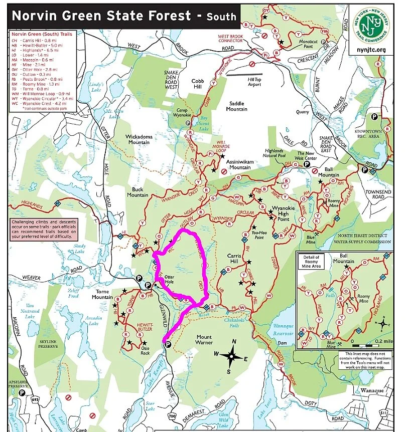
I started at the Chickahoki parking area on Otter Hole Road/Glenwild Avenue, following the eastern portion of the Wyanokie Crest trail (yellow blaze) in a very large circle until it intersected with the Otter Hole trail (green blaze), at which point I took the Highlands Trail (teal blaze) back to the Wyanokie Crest that acts like a spur trail to the parking lot.
Since words can’t really describe it I’m not going to tarry in getting you to the photo gallery. I consciously took pictures of the trail at my feet throughout this journey because of the terrain. You’re welcome.
Now get out there and explore!
Norvin Green State Forest
Otter Hole and Wyanokie Crest East
Total Mileage:
3.89 miles
Total Elevation:
781 feet

The parking lot only fits three cars because of the fire road entrance, but there is decent pull off space by the road to fit an additional 3 -4 cars, more if folks are creative. With the trees on the side of the road it does get a little tight, and personally I wouldn't want my car hanging on the shoulder of this road.

Chikahoki fire road/Wyanokie Crest trail entrance. The kiosk is decent but doesnot have a map displayed. Bring a map, or get the Avenza Maps app. The NY/NJ TC map for this area is a FREE download!

How fun is it to say "Chikahoki"?

The trail peels off immediately from the fire road, though there are a few places where they get real close to one another.

Be more erratic!!

Still not decidedly very green in Norvin Green.

The terrain is constantly changing on this loop. You won't go more than ten steps without a new section underfoot.

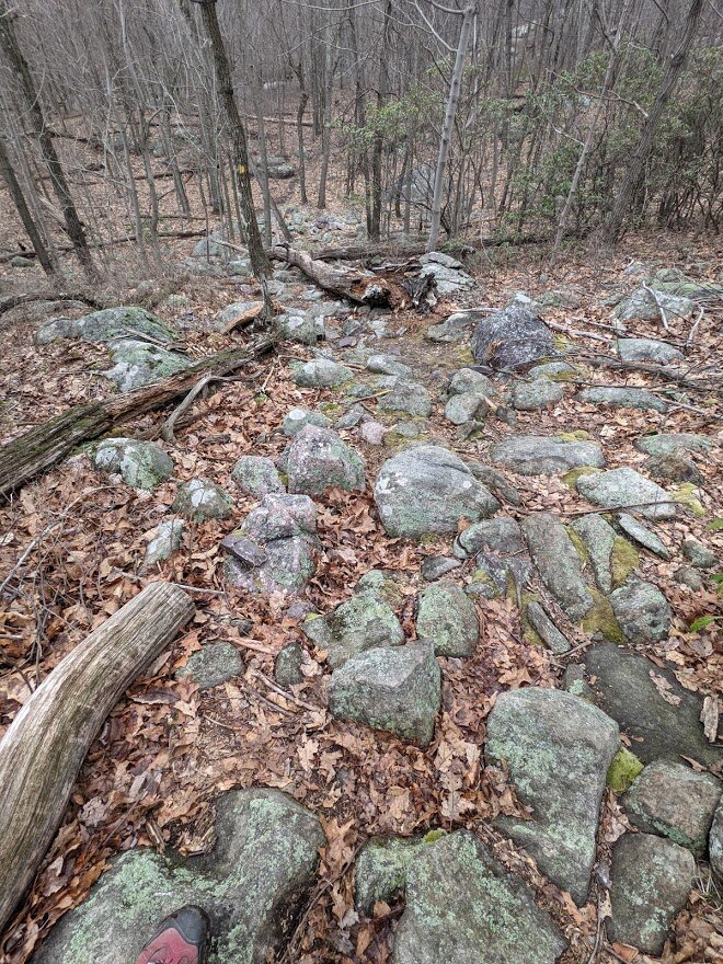
Right out of the gate: bam! Boulder field. These are close enough together than it is easier to walk atop them than between them.

And then, look! Smooth. Nicely graded. A little wider for your comfort.

Then you come to Posts Brook.

Posts Brook had expanded due to rainfall since my last visit. It was much tougher to get across as the smaller rocks I'd hopped previously were now under water.

I used my poles for this section of the trail. Better to use poles than to fall in the drink, I always say!

This is pretty much what it looked like. There are three distinct run throughs of Posts Brook at this crossing. With the rainfall, they had all seeped together into one.

The third (and easiest) crossing.

Poor tree. Before you carve into a tree, think about its dignity, please.

Looking back toward Posts Brook. Glad to have the crossing over!

I continued north on the eastern side of the Wyanokie Crest trail (yellow blaze).

Shortly after Posts Brook the trail intersects with the Highlands Trail (teal blaze) and I believe the Hewitt-Butler (blue blaze) but the blue blaze here might actually go by another name.

Dreamy. Just dreamy walking.

The trail follows this brook for a very long time, but the map gives it no name. If it were up to me, I would call it Rock Brook.

Aw, see? What'd I tell you. From smooth to root....

... and from root to rock.

The trail follows rock brook until it begins the climb at its northern most point. It's a significant brook that runs year round. Not sure why it isn't named....

But this is why I call it Rock Brook. The water falls over rock of various sizes, and the further north you go, the larger the specimen of rock.

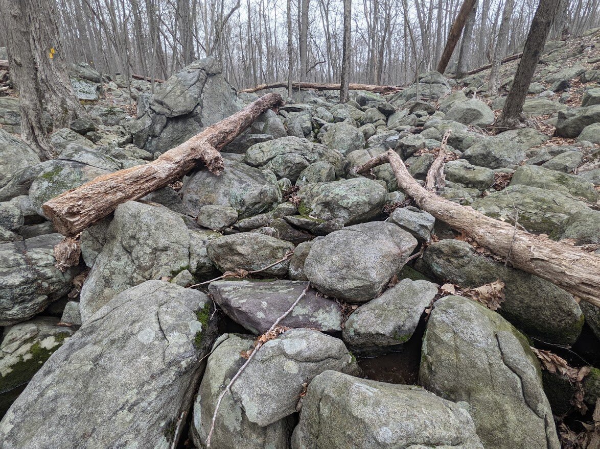
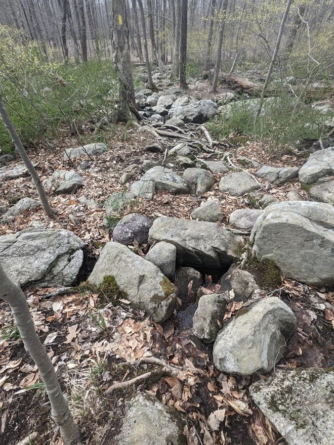
The trail crosses the brook where the "rocks" have turned to magnificent boulders, and yes! You get to cross them!!!

The photo doesn't quite capture the scale of these boulders. I could lie down on almost all of them and be quite comfortable.

But as soon as you get across the boulder field.... ? You guessed it: completely opposite terrain.

Not much further and old blow downs are mangled together on the trail, and there isn't a way around. They are not difficult to pick around, though.

After the giant boulder crossing, you swing away from Rock Brook briefly, and then head back toward it.

The brook is still rocky.

And so is the trail.

I couldn't quite capture the beautiful waterfall that was cascading through the rocks.

Slowly, you gain in elevation beside Rock Brook, and there is a tiny rock scramble that overlooks the water as it trickles down to meet Posts Brook.

This section was a little bit gnarly because of the boulders and blow downs. You can't really easily go around the tree because of the way it lies across the trail and the shape of the rocks, but being short I had no problem ducking beneath it and continuing on.

This Eastern Newt was so teeny weeny and adorable! He was just chillin' on a rock, doing his little newty thing.

Rock Brook begins as a swamp, and as you can see, it is mucky and thick and gooey.

One last crossing of unnamed/my name: Rock Brook before climbing out of the swamp and into the higher elevations. The frogs were singing all around me.

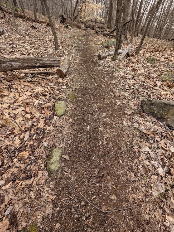
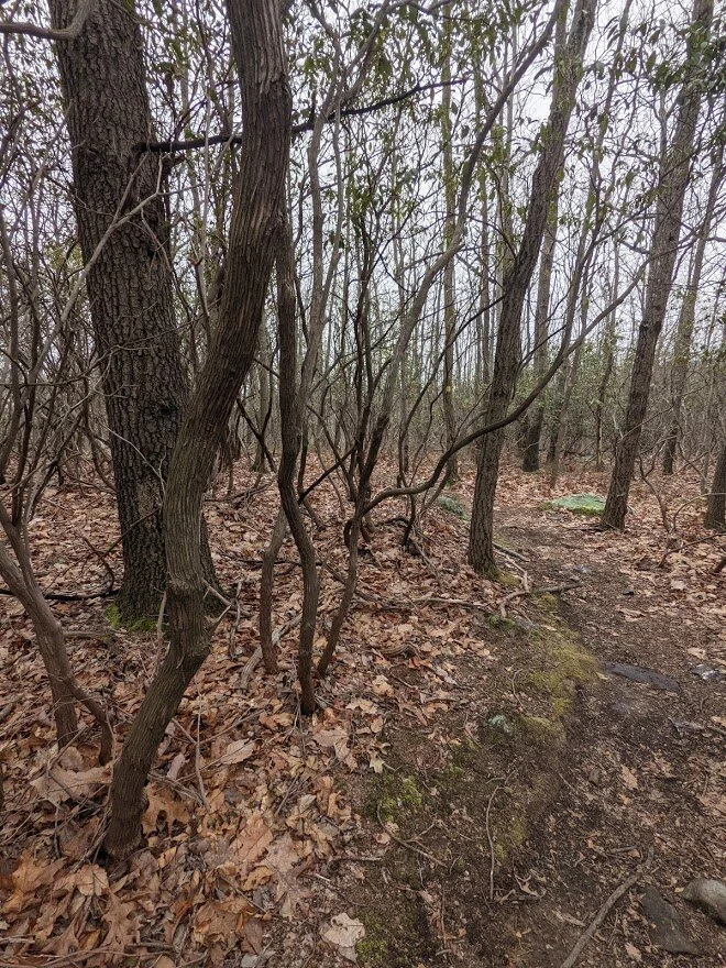
Out from the roots, rocks, blown downs, and muddy bog.... BACK TO SMOOTH AWSOME TRAIL (don't worry: that'll change)
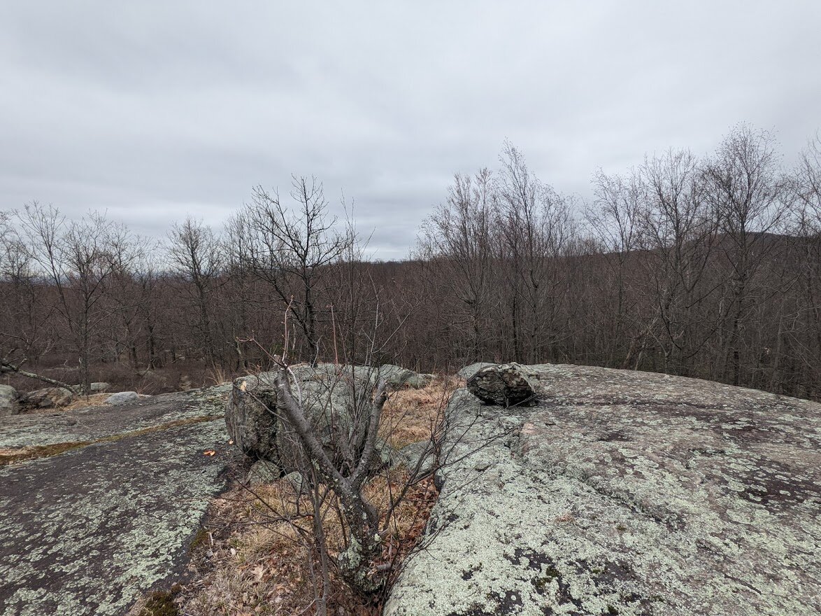
Topping out at 900', there isn't much of a view but it is a nice, exposed hill top that provides a bit of a breeze.

Without the leaves on the trees, there is a clear view of neighboring Carris Hill in the distance.

Aaaaaand... just like that you're back to roots and rocks.
Why yes, yes that IS the trail.

Be more erratic! Actually, this section was fun as it weaved in and out of giant glacial erratic. This is the highest point on the trail at 1,000'.

Just after cresting the hill top, the Wyanokie Crest intersects with the OUTLAW trail (orange blaze). Who wouldn't want to hike a trail called OUTLAW? I do. But I didn't on this particular day. That's for another adventure. An OUTLAW adventure.

I just have music of the old west going through my head whenever I see the blaze for the Outlaw trail.

After a quick descent while the trail changes to a south-westerly direction, there is a scenic viewpoint of Buck Mountain.

Welcome to yet another terrain change! Pebbles and slender roots grace the trail through a thicket of rhododendron.

Quite well worn, but it works!

A second, but less interesting viewpoint emerges with terrain of cliffside rock.

I'm glad I wore Oboz - they grip the rock really well and I wasn't worried about plunging down the side of the steep hill.

Then back again into another thicket of rhodos. This one even more dense than the first.
I loved the look and the shape of the trunks.

And as soon as you pass through the thicket of rhododendrons, it's back to a trail compiled of varying sized rocks. And it's downhill, which is super fun. I tripped up a toe on my way down and thank goodness there was a tree in front of me to break my fall or I would have had some serious injuries.

After a tiny creek crossing, Wyanokie Crest intersects with Highlands Trail (teal blaze) and Otter Hole (green blaze). If you were to continue west on the Wyanokie Crest, you would be climbing up Buck Mountain.

I had come from this direction on my April 8th hike.

Then it was off on the Highlands Trail back to the portion of the Wyanokie Crest that I came in on.

The Highlands here is like a woods road from over use, even though it is a defined as a single track trail. This is a major artery through Norvin Green to the most scenic spots: Carris Hill, Otter Hole, Wyanokie Crest (east and west) and Chikahoki Falls.

It is very well maintained and the terrain is pretty easy, even though it is continuously dappled with rock.

Eventually I came back to my starting point of the loop and turned south to head back to the Glenwild Avenue parking area.

But not before passing by this really interesting fungus.
Oh, and I forgot: the rocky terrain.

With the multiple crossings of Posts Brook.

And then it's soft and smooth...

... until it's not....

... all the way back to the parking area.