

Where am I going?
Highlight Hiker Blog
Appalachian Trail & Abram S. Hewitt State Forest
June 25, 2020. I hiked the AT from Longhouse Road into Abram S. Hewitt State Forest, walking around the Ernest Walker loop (yellow blaze), to the State Line (blue blaze) back to Longhouse Rd. via the AT. It was a hard earned 7.10 miles with 1,726' elevation gain in 4:49. I took all kinds of photos. I was climbing hand over hand on rock scrambles. I had to drop my pack and jump down a few small rock faces. I didn't bring enough water. But I was happy and grateful and proud of myself for the accomplishment. And the views! OH! The views! From the marsh to the ridge, the views were everywhere. Not just the viewpoints listed on the map, but dotted all along the way. It was worth every amount of effort. A few things about this section: #1. If you plan to hike the Ernest Walker loop, I advise you to leave your canine companion at home. This isn't a good loop for dogs unless they are incredibly agile, and even then I would leave my incredibly agile dog at home. It's just too much risk for injury for your four legged BFF, if you ask me. #2. If you're short, like me, you're going to have to work a little harder in some spots than your long legged bipedal companions. Work out your problems by finding the line before you commit. You might want to use one of the reroutes vs. risking the slip and fall. #3. Bring more water than you think you'll need, and then bring a reserve. Exposed ridge walking in the summer heat is not for everyone. I like it, but even I didn't bring enough water for that amount of exposure. #4. Trekking poles aren't going to help you over most of the rock, especially the hand over hand sections. I used mine once, and then put them away. I found it was a bigger pain (and time suck) to take them in and out of my pack than the benefit of using them. #5. The difficulty level of this hike will solely depend on your fitness level. I wouldn't say it's terribly difficult, but I certainly wouldn't advise someone new to hiking to start here. These trails will use your body in a non-linear way. #6. The 2017 version of the NY/NJ Trail Conservancy maps are totally outdated on this hike, especially the AT section. Expect to find a lot more seasonal creeks, bridges unmarked trails and woods roads than shown on the map. Use your favorite GPS app if you have any doubts about where you are, or what direction you should be moving.
The photo album is huge. There was just too much good stuff to see! Flip through it at your leisure (please make sure you pronounce that "lezz-zure").
Enjoy!

The parking pull off on Longhouse Road. Two or three cars can fit here. Parking is only available on the nobo side of the road. The AT continues to the east a short way down the road. Watch for the trail markers, though: there is a wide unmarked trail before the actual AT.

As is typical with the AT, the scenery seems to be a bit more beautiful than it's neighboring trails.

There's something awe inspiring about those long white blazes of the AT!
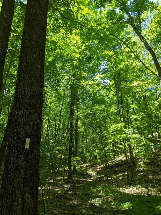
It's so green in the forest that the white blaze looks green, too!

These trees seemed to stand a little taller, a little prouder. It's like they know how lucky they are and are saying, "Look at me! I'm a tree on the AT, bitches!"

The terrain here is pretty rocky, but it's still easy. You can make good time if you don't stop to take pictures every other step!

The first crossing is over an unnamed creek. There are several seasonal creeks that were dry on my journey in the latter part of June, but this one was still flowing. Better water is ahead, though, if you need water. This creek and the other seasonal creeks, are not marked on the map. As are several woods roads and unmarked trails leading from the nearby residential areas.

Another Scout bridge! I love finding Eagle Scout bridges in the wilderness. I admire them for the amount of work that needed to be done to create it. Someone had to haul all of that lumber out into the woods on a single track trail. Even with a cart, that isn't an easy task. And it's a very well constructed bridge, too.

View from the Bridge facing a southerly direction

View from the bridge facing a northerly direction.

And then, just like that, a field/marsh appears to the south filled with birds and frogs and wildlife. You'll hug this field, which turns into marsh, for quite awhile.

Long House Creek

The footbridge over Long House Creek.

Long House Creek from the footbridge facing south

Long House Creek facing north. This is a much better water source than the previous creek.

Long House Creek turns into a marsh, which eventually feeds into Upper Greenwood Lake. The marsh is so pretty it's worth taking the detour (not listed on the map although it's clearly a woods road) of this hand-marked yellow/red blaze trail ahead.

When the AT meets the red/yellow blaze, head south (turning right) for a short detour. It's really worth the fifteen minutes you'll spend to see the marsh from its eastern edge.
Where the AT meets this local trail.

A wide woods road that floods frequently in the wet/rainy season. Be prepared for mosquitoes to accompany you on this short detour.

Love that symbol!!

You were just walking on the other side of this marsh!

Looking south

Looking north

A little further gives you a better viewpoint. Facing south.

The AT is on the other side, but you couldn't see this from there!

The mountain laurels are still blooming...

... but just barely.

You start to see signs of higher elevation before you meet the Ernest Walker trail. Ridge lines begin to appear under your feet.

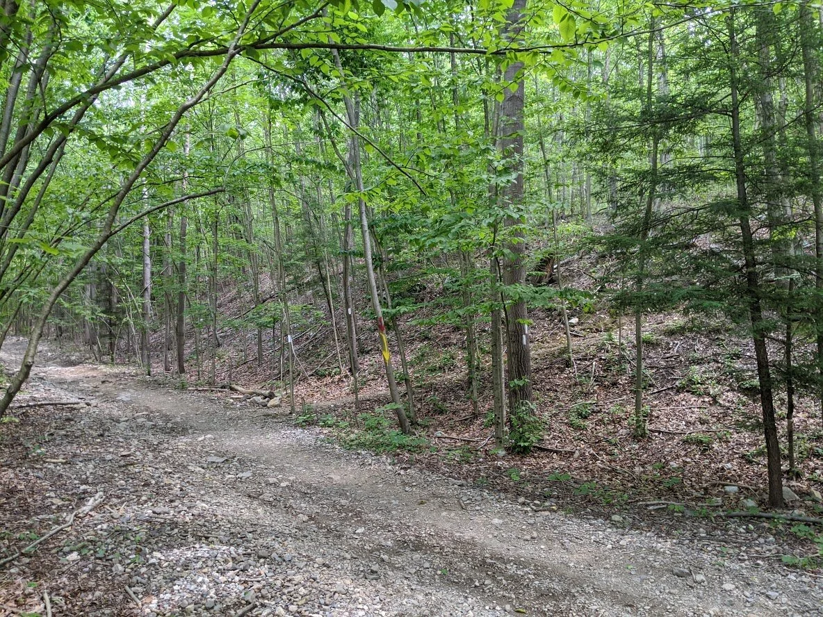
Where the AT meets the Ernest Walker loop.

Ernest Walker trail head.

The EW (yellow blaze) is, overall, a ridge walk. And who has two thumbs and loves ridge walks??? Your Truly. You'll climb to nearly 1400' on the western side of the loop.

I love walking on the spine of a mountain. It makes me feel like I'm on the back of a dinosaur. Or a dragon. Or Pete's Dragon.

At the higher elevations on the western edge of the loop, you'll be walking in a forest of evergreen. I wish I could have recorded the scent for you! It's immersive and wonderful.

You don't have long vistas on the ridge, but it's gorgeous nonetheless!

The Ernest Walker takes a hard turn east. There is an unmarked trail that continues to follow the ridgeline to the highest point in the surrounding parks at 1437', but there is no scenic viewpoint from there, and the hike is discouraged by the park.

But it's worth it when you take the unmarked side trail to the (listed) scenic viewpoint over West Pond. These interesting view points make the effort of scrambling worthwhile.

You can easily tell when you've reached the eastern ridge line.

And that's just the beginning of the views. This one IS marked, but many others along the way are not. You can see the top of the NYC skyline from every point along this edge of the trail.

Green top mountains for days!

After that viewpoint, you'll scramble down and into this crazy old rhododendron field.

Most of the flowers are above you. Their blooming season is short, but so pretty. You'll have to stop and look up to see them because the forest floor is a tangle of roots and rocks.

And it continues on...

Where the Quail (orange blaze) meets with the Earnest Walker, the trail will widen, but only for a short distance.

Heavy foot traffic on both trails converge to this scenic viewpoint at Surprise Lake. I don't think swimming is discouraged here, but it certainly isn't easy to get into the water, so signage might not be needed. There were a lot of folks here when I arrived (among them some very loud teenagers) so I only lingered long enough to take one photo and I pushed on.

This was my one photo. There were other view points, but they were crowded and then teens were threatening to push each other in, so I just walked away.

Back to the ridge? Don't mind if I do!

Viewpoint #1. Each one is better than the last when you're hiking nobo! This is definitely the right approach.

The ridge on this side of the mountain is much wider than it's western cousin.

Viewpoint #2 (keep in mind that these aren't marked on the map), though they are all awe inspiring.

Viewpoint #2.

Viewpoint #2.

Viewpoint #3. This is the only starred view on the map.

Viewpoint #3. (That's Greenwood Lake below. My friend lives there. I shouted hello to my friend from this viewpoint. I'm pretty sure she heard me.)

Viewpoint #3. From up here you can hear the boats on the lake and lots of laughter and happy shouting.

Viewpoint #3.

Viewpoint #3.

Viewpoint #3.

Viewpoint #3.

You come down off the ridge quick and sharp, and the Ernest Walker ends at the State Line trail (blue blaze). It was around this point that I realized I underestimated my water intake).

You just climbed down the ridge line about 100' to get here. Now you're about to climb 200'+ feet to get back to where you came from.

Rocky. The whole way. Ridgey and rocky.

But it doesn't take long before you come to the trail head for the State Line, and meet back up with the AT.

And it's marked so well! We're headed sobo from here.

The last viewpoint lies just between the trees.

You can only travel one way from here: UP...

... but eventually you'll pass by the Ernest Walker trail head, and then it's back to Longhouse Road and the parking lot the way you came in on the AT. Since it's almost all downhill, the trip back is pretty fast. Just watch your footing! Loose stones can trip you up along this section while you're descending from the 300' (approximately) down to the road.

To get from the western ridge line to the eastern ridge line, you're going to work hard up and down more than 500'.

Yes. That IS the trail. Looking up. See the slab on the bottom of the photo? That was my eye height.

Oh! You want me to climb hand over hand some more? Ok.
